


Precinct 4, Gallatin County, Montana
About
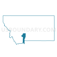
Outline

Summary
| Unique Area Identifier | 612028 |
| Name | Precinct 4 |
| County | Gallatin County |
| State | Montana |
| Area (square miles) | 106.32 |
| Land Area (square miles) | 105.96 |
| Water Area (square miles) | 0.37 |
| % of Land Area | 99.65 |
| % of Water Area | 0.35 |
| Latitude of the Internal Point | 45.49960480 |
| Longtitude of the Internal Point | -111.01367940 |
Maps


Graphs
Select a template below for downloading or customizing gragh for Precinct 4, Gallatin County, Montana


Neighbors
Neighoring Voting District (by Name) Neighboring Voting District on the Map
- 5-A Emigrant, Park County, MT
- 6-A Richland, Park County, MT
- Precinct 2, Gallatin County, MT
- Precinct 21, Gallatin County, MT
- Precinct 22, Gallatin County, MT
- Precinct 23, Gallatin County, MT
- Precinct 3, Gallatin County, MT
- Precinct 6, Gallatin County, MT
Top 10 Neighboring County Subdivision (by Population) Neighboring County Subdivision on the Map
- Bozeman CCD, Gallatin County, MT (49,560)
- Livingston CCD, Park County, MT (12,325)
- Gallatin Gateway CCD, Gallatin County, MT (4,839)
- Big Sky CCD, Gallatin County, MT (2,195)
Top 10 Neighboring Elementary School District (by Population) Neighboring Elementary School District on the Map
- Bozeman Elementary School District, MT (51,460)
- Arrowhead Elementary School District, MT (1,909)
- Gallatin Gateway Elementary School District, MT (1,565)
- Anderson Elementary School District, MT (1,154)
- La Motte Elementary School District, MT (843)
- Cottonwood Elementary School District, MT (233)
Top 10 Neighboring Secondary School District (by Population) Neighboring Secondary School District on the Map
Top 10 Neighboring State Legislative District Lower Chamber (by Population) Neighboring State Legislative District Lower Chamber on the Map
- State House District 70, MT (11,732)
- State House District 63, MT (10,738)
- State House District 61, MT (9,919)
Top 10 Neighboring State Legislative District Upper Chamber (by Population) Neighboring State Legislative District Upper Chamber on the Map
- State Senate District 35, MT (26,667)
- State Senate District 32, MT (23,354)
- State Senate District 31, MT (18,534)
Top 10 Neighboring 111th Congressional District (by Population) Neighboring 111th Congressional District on the Map
Top 10 Neighboring Census Tract (by Population) Neighboring Census Tract on the Map
- Census Tract 5.02, Gallatin County, MT (4,908)
- Census Tract 12, Gallatin County, MT (4,839)
- Census Tract 2, Park County, MT (4,067)
- Census Tract 16, Gallatin County, MT (2,195)
- Census Tract 5.01, Gallatin County, MT (1,940)